
16.04.2026
Trickle-down effect
Evidence suggests that the El Niño phenomenon is of increasing frequency and intensity, with the possibility of a ‘super’ event any time soon. Anthropogenic global warming could easily be a big influence, writes Eddie Ford
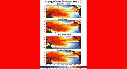
El Niño is a long recognised natural climate pattern that was first systematically remarked upon, so it seems, by fishermen off South America’s coast in the 1600s - its name meaning ‘The Little Boy’ (or ‘Christ Child’) in Spanish. It is a climate event in which surface sea-water temperatures in the central and eastern tropical Pacific Ocean are warmer than average, and the entire natural climate cycle is officially known as El Niño Southern Oscillation (Enso) - with the subsequent cooling phase known as ‘La Niña’ (‘The Little Girl’).1
Basically then, when surface water temperatures are warmer than average in the eastern equatorial Pacific Ocean, you have El Niño - and when they are cooler than average, you have La Niña. It is important to note that Enso - an irregular pattern, but with some semblance of cycles - is not predictable in any certain sense and it effects the climate of much of the tropics and subtropics, and has links to higher-latitude regions of the world (or ‘telecommunications’, which in atmospheric science refers to climate anomalies being related to each other).
El Niño, more broadly, is associated with higher-than-normal air sea-level pressure over Indonesia, Australia and across the Indian Ocean to the Atlantic - while La Niña has roughly the reverse pattern: high pressure over the central and eastern Pacific and lower pressure through much of the rest of the tropics and subtropics. The two phenomena last a year or so each and typically occur every two to seven years with varying intensity, with neutral periods of lower intensity interspersed. Generally speaking, El Niño events can be more intense, but La Niña events may repeat and last longer. The relative frequency of both can affect global temperature trends on timescales of around 10 years. However, showing the planet is consistently warming, a La Niña year now is warmer than an El Niño year was just a few decades ago.
It is also important to understand that each country that monitors the Enso has a different threshold for what constitutes an El Niño or La Niña event, which is tailored to their specific interests, and, fairly logically, the countries most affected are developing states bordering the Pacific Ocean that are dependent on agriculture and fishing.
Powerful
Many forecasters are predicting the possibility that a powerful, ‘super’ El Niño will take effect this year. This is not a formal term amongst climate scientists: it just means one that is stronger than normal - typically defined by sea surface temperatures spiking up by at least 2°C.2 In fact, according to the National Oceanic and Atmospheric Administration, it could be the strongest El Niño in at least a decade, spurring punishing drought in some regions and severe storms in others - while also causing the Earth’s temperature to rise even further, which is alarming, to say the least.3 Indeed, it is believed that a Mega El Niño actually instigated the end-Permian mass extinction, which occurred about 252 million years ago.4
The NOAA, for one, believes that El Niño could begin this spring or summer - meaning that sea surface temperatures are quickly changing in the equatorial Pacific, as most El Niño events typically begin in the autumn. Hence the latest report added that there is a 25% chance of a “very strong” El Niño and a 50% chance of a “strong” one, with Pacific Ocean temperatures rising to at least 1.5°C warmer than average. This phenomenon is “often characterised by chaos, because it shifts global weather and introduces new extremes”, to further use the words of the report. We know all this by the use of satellites that track the ocean temperatures and an array of research buoys. They deploy probes more than 300 metres underwater to monitor the depths of warming. Warmer water underneath the surface rises over the course of several months to feed potential El Niño conditions. The larger the temperature increase, the stronger the El Niño could be.
Depending on its strength, naturally, El Niño’s effects can be very far-reaching, influencing storm patterns, drought, wildlife populations, and even how fast the Earth spins. Warmer waters in the central and eastern parts of the tropical Pacific could mean more intense storms there - and, of course, those storms can influence weather across the globe. The impact of El Niño can have a trickle-down effect on wildlife populations, for example. A 2006 study in the journal, Biological Conservation, outlines the way the penguin population on the Galápagos Islands severely crashed after two strong El Niño events in the 80s and 90s.5 The warming oceans caused by the weather patterns reduced the number of macronutrients and fish in the water, which in turn may have starved the penguin population.
Perhaps paradoxically, Enso predictions - insofar as you can make them - can help people around the world prepare for coming shifts in extreme weather, so can be regarded as an essential tool in a warming world. As explained by Emily Becker, a research professor at the NOAA, El Niño influences the global atmosphere in such a way that “we have a greater chance of knowing where things are going to happen” - thus giving us the “capability of seeing potential outcomes that really gives us a nice advantage”. We can also see this paradoxical or advantageous effect when we examine the relationship between El Niño and the Atlantic hurricane season. El Niño increases wind shear - strong vertical gusts that break apart storms as they form - and this, combined with the fact that parts of the Atlantic Ocean are not as warm as they were last year, could make for a less intense season. For this reason, Becker hesitates to characterise El Niño or La Niña as “good or bad” - rather, “they just are, and pretty much always have been”.
Having said that, and, while it is not “a slam dunk” - as a leading climate scientist said in a briefing last week - all the ingredients for El Niño are there. Yes, forecasts in spring cannot account for unexpected changes that can happen over the summer, but the risks are high enough that it is only right to be worried. A strong El Niño would put 2027 in the running to break global heat records, boosting global temperatures by around 0.2°C, and could produce a series of devastating effects, ranging from supercharged rainstorms to drought, depending on the region of the world.
Uncertainty
In this vein, a BBC article on recent climate developments asks - “Is a ‘Super El Niño’ on the way”?6 The writer, Sarah Keith-Lucas, points out that La Niña is still weakly present in the Pacific Ocean, and has largely been in charge since December 2024 - leading to a temporary lowering of global temperatures, which meant that 2025 was a slightly cooler year than 2024 (the world’s hottest year on record). But she quotes the Australian Bureau of Meteorology saying this current La Niña “is close to its end”, and the NOAA is forecasting a “transition from La Niña to Enso-neutral” conditions in the next month, lasting until early in the northern-hemisphere summer - then between June and August there is a 62% chance that El Niño will emerge “and persist through at least the end of 2026”.
In other words, there remains a lot of uncertainty about the course things will take. But the BBC’s Keith-Lucas believes there are “hints” that this upcoming El Niño could become a “strong” event. There were a few months of a strong El Niño in late 2023, but the most recent sustained period was during 2015-16 and this made 2016 the hottest year on record at that time (overtaken now by 2023, 2024 and 2025) - as well as seeing multiple other records broken and extreme weather events. We saw, for instance, 16 tropical cyclones in the central Pacific hurricane basin, including the first recorded instance of three Category 4 storms simultaneously across the central and eastern Pacific. Meanwhile, of course, global sea levels continued to rise, and Arctic sea ice extent was well below average.
As the BBC article reminds us, no two El Niño events are the same, but certain weather patterns are more or less likely when it develops. This can normally be found in places closest to the unusually warm Pacific waters like Australia, Indonesia and the Philippines, with drought and forest fires often becoming major problems. But on the other side of the Pacific, countries in South America such as Peru and Ecuador can see much wetter weather, leading to devastating floods. You can also get flooding from winter rainfall in the south-west US.
As for the UK, Enso impacts can often lag behind the actual event - but the effect on the UK’s weather may be stronger during the later winter months. El Niño years, say climate scientists at the Met Office, are “one factor that can increase the risk” of colder winters in Britain. This is on top of the warning that the Atlantic Meridional Overturning Circulation (Amoc), or ‘North Sea drift’ - which gives a country like the UK its famously moderate climate - could seriously weaken, or even switch off. This appeared to be the case about 12,900 years ago, when in North America the melting of the giant frozen Lake Agassiz caused large amounts of fresh water to flood into the sea - an event probably caused by a comet impact, which was followed by 1,300 years of freezing.7
Amplified
Is global warming responsible for this probable ‘strong’ or ‘super’ Enso? The link is not clear-cut or unambiguous. However, evidence strongly suggests that both El Niño and La Niña events may be increasing in frequency and strength.8 As the Climate Prediction Center puts it, this “amplified cycle” translates into more frequent Enso-linked droughts, floods, heat waves, wildfires and severe storms.
Three years ago, after looking at more than 40 models of the climate for five years, Dr Wenju Cai of Australia’s Commonwealth Scientific and Industrial Research Organisation said that they showed a “human fingerprint” from 1960 onwards - meaning that climate change had likely made both El Niños and La Niñas “more frequent and more extreme”.9 In the opinion of Cai, the research clearly demonstrates that “we are experiencing a vastly different climate to that of the distant past” and therefore Enso will change in the future, “given sea surface temperatures are continuing to increase”.
Of course, not everyone agrees that greenhouse gas warming has influenced or shaped Enso. Some raise concerns about the reliance on modelling and others point to the fact that Enso is hugely variable, so the research can never be conclusive or definite. Science, after all, is based on the open clash of different and contending ideas, which is the essential premise of Marxism as well. The Weekly Worker exists to put that into practice.
-
en.wikipedia.org/wiki/El_Ni%C3%B1o%E2%80%93Southern_Oscillation.↩︎
-
theguardian.com/environment/2026/apr/13/el-nino-explainer.↩︎
-
nationalgeographic.com/environment/article/super-el-nino-extreme-weather-climate.↩︎
-
sciencedirect.com/science/article/abs/pii/S0006320705003095.↩︎
-
climate.gov/news-features/blogs/enso/has-climate-change-already-affected-enso.↩︎
-
theguardian.com/environment/2023/may/18/global-heating-el-nino-la-nina-weather-climate-pattern-more-frequent-extreme.↩︎